File:Swine flu infection exponent by county June 2009.svg
From LIMSWiki
Jump to navigationJump to search
Size of this PNG preview of this SVG file: 555 × 352 pixels. Other resolutions: 320 × 203 pixels | 640 × 406 pixels | 800 × 507 pixels | 1,024 × 649 pixels | 1,280 × 812 pixels | 2,560 × 1,624 pixels.
Original file (SVG file, nominally 555 × 352 pixels, file size: 1.35 MB)
Summary
| Description |
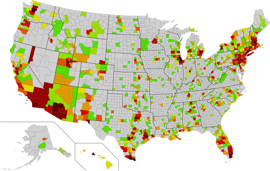
English: Number of swine flu cases per county. Mostly June 19 2009 but some state data is up to one month out of date. Utah, Virginia, and Minnesota are colored according to health service zones made up of several counties, each of which is colored by the average value - average below 1.0 is not colored. See "references and notes" below for full details.
The color scheme is green -> red -> black with successive shades beginning at powers of 2 (1, 2, 3-4, 5-8 ... to 1024-2048 for Chicago and New York). See legend below. This file is based on the public domain blank U.S. map with counties labeled by FIPS code, file:USA Counties with FIPS and names.svg. It can be colored by opening the .svg in a text editor and adding FIPS codes before the appropriate fill color.Español: Número de casos de la gripe A (H1N1) por condado. Algunos están actualizados al 19 de junio de 2009, pero algunos están más actualizados. Utah, Virginia y Minnesota están coloreados de acuerdo con los centros de salud de cada condado, cada uno de la cual están coloreados con el valor promedio - menos de uno 1.0 no están coloreados. |
| Date | 23 June 2009, 07:00 (UTC) |
| Source | |
| Author |
|
See the following table of references and notes for further information:
Legend:
1 case
|
9-16 cases
|
129-256 cases
|
2 cases
|
17-32 cases
|
257-512 cases
|
3-4 cases
|
33-64 cases
|
513-1024 cases
|
5-8 cases
|
65-128 cases
|
1025-2048 cases
|
| Tabular data | ||||
|---|---|---|---|---|
| State | Counties by Alphabet | Confirmed cases | Deaths | |
| AK | Anchorage | 4 | ||
| AK | Fairbanks North Star | 11 | ||
| AK | Haines | 2 | ||
| AK | Matanuska-Susitna | 1 | ||
| AK | Sitka | 2 | ||
| AK | Skagway-Hoonah-Angoon | 2 | ||
| AL | Autauga | 1 | ||
| AL | Baldwin | 6 | ||
| AL | Barbour | 1 | ||
| AL | Blount | 1 | ||
| AL | Clay | 1 | ||
| AL | Coffee | 10 | ||
| AL | Colbert | 2 | ||
| AL | Covington | 3 | ||
| AL | Dale | 9 | ||
| AL | Elmore | 1 | ||
| AL | Etowah | 22 | ||
| AL | Houston | 4 | ||
| AL | Jackson | 1 | ||
| AL | Jefferson | 18 | ||
| AL | Lee | 14 | ||
| AL | Limestone | 2 | ||
| AL | Madison | 43 | ||
| AL | Marshall | 4 | ||
| AL | Mobile | 5 | ||
| AL | Monroe | 1 | ||
| AL | Montgomery | 20 | ||
| AL | Morgan | 1 | ||
| AL | Pike | 2 | ||
| AL | Shelby | 8 | ||
| AL | St. Clair | 1 | ||
| AL | Talladega | 1 | ||
| AL | Tuscaloosa | 1 | ||
| AR | Craighead | 4 | ||
| AR | Lawrence | 1 | ||
| AR | Pulaski | 6 | ||
| AR | Sebastian | 5 | ||
| AR | Washington | 1 | ||
| AZ | Apache | 1 | ||
| AZ | Cochise | 2 | ||
| AZ | Coconino | 6 | ||
| AZ | Gila | 2 | ||
| AZ | Graham | 5 | ||
| AZ | La Paz | 1 | ||
| AZ | Maricopa | 354 | 1 | |
| AZ | Mohave | 2 | ||
| AZ | Navajo | 6 | ||
| AZ | Pima | 140 | 1 | |
| AZ | Pinal | 73 | 5 | |
| AZ | Santa Cruz | 7 | ||
| AZ | Yavapai | 2 | ||
| AZ | Yuma | 44 | ||
| CA | Alameda | 54 | 2 | |
| CA | Amador | 1 | 0 | |
| CA | Butte | 3 | 0 | |
| CA | Calaveras | 1 | 0 | |
| CA | Contra Costa | 117 | 2 | |
| CA | El Dorado | 6 | 0 | |
| CA | Fresno | 1 | 0 | |
| CA | Humboldt | 1 | 0 | |
| CA | Imperial | 68 | 0 | |
| CA | Kern | 3 | 0 | |
| CA | Kings | 6 | 0 | |
| CA | Los Angeles | 97 | 1 | |
| CA | Madera | 3 | 0 | |
| CA | Marin | 19 | 0 | |
| CA | Merced | 2 | 0 | |
| CA | Monterey | 15 | 0 | |
| CA | Orange | 72 | 1 | |
| CA | Placer | 4 | 0 | |
| CA | Riverside | 77 | 0 | |
| CA | Sacramento | 24 | 0 | |
| CA | San Benito | 1 | 0 | |
| CA | San Bernardino | 108 | 1 | |
| CA | San Diego | 212 | 1 | |
| CA | San Francisco | 10 | 0 | |
| CA | San Joaquin | 10 | 0 | |
| CA | San Luis Obispo | 23 | 0 | |
| CA | San Mateo | 15 | 0 | |
| CA | Santa Barbara | 14 | 0 | |
| CA | Santa Clara | 74 | 0 | |
| CA | Santa Cruz | 3 | 0 | |
| CA | Shasta | 1 | 0 | |
| CA | Solano | 1 | 0 | |
| CA | Sonoma | 5 | 0 | |
| CA | Stanislaus | 1 | 0 | |
| CA | Sutter | 1 | 0 | |
| CA | Tehama | 4 | 0 | |
| CA | Tulare | 7 | 0 | |
| CA | Ventura | 10 | 0 | |
| CA | Yolo | 2 | 0 | |
| CO | Adams | 17 | ||
| CO | Arapahoe | 19 | ||
| CO | Archuleta | 1 | ||
| CO | Boulder | 4 | ||
| CO | Denver | 21 | ||
| CO | Douglas | 4 | ||
| CO | Eagle | 3 | ||
| CO | El Paso | 6 | ||
| CO | Fremont | 1 | ||
| CO | Garfield | 8 | ||
| CO | Jefferson | 10 | ||
| CO | La Plata | 1 | ||
| CO | Larimer | 2 | ||
| CO | Mesa | 1 | ||
| CO | Morgan | 1 | ||
| CO | Pitkin | 2 | ||
| CO | Weld | 1 | ||
| CT | Fairfield | 390 | ||
| CT | Hartford | 76 | 1 | |
| CT | Litchfield | 13 | ||
| CT | Middlesex | 5 | ||
| CT | New Haven | 241 | 3 | |
| CT | New London | 9 | ||
| CT | Tolland | 25 | ||
| CT | Windham | 4 | ||
| DC | District of Columbia | 33 | ||
| DE | Kent | 26 | 0 | |
| DE | New Castle | 156 | 0 | |
| DE | Sussex | 8 | 0 | |
| FL | Alachua | 5 | ||
| FL | Bradford | 1 | ||
| FL | Brevard | 7 | ||
| FL | Broward | 84 | ||
| FL | Clay | 2 | ||
| FL | Collier | 8 | ||
| FL | DeSoto | 1 | ||
| FL | Duval | 6 | ||
| FL | Escambia | 13 | ||
| FL | Flagler | 1 | ||
| FL | Hamilton | 1 | ||
| FL | Hernando | 1 | ||
| FL | Highlands | 1 | ||
| FL | Hillsborough | 37 | ||
| FL | Indian River | 1 | ||
| FL | Lake | 13 | ||
| FL | Lee | 22 | ||
| FL | Leon | 1 | ||
| FL | Levy | 2 | ||
| FL | Manatee | 4 | ||
| FL | Marion | 3 | ||
| FL | Martin | 25 | ||
| FL | Miami-Dade | 151 | 1 | |
| FL | Nassau | 2 | ||
| FL | Okeechobee | 1 | ||
| FL | Orange | 43 | ||
| FL | Osceola | 8 | ||
| FL | Palm Beach | 34 | ||
| FL | Pasco | 9 | ||
| FL | Pinellas | 12 | ||
| FL | Polk | 24 | ||
| FL | Santa Rosa | 2 | ||
| FL | Sarasota | 5 | ||
| FL | Seminole | 18 | ||
| FL | St. Johns | 3 | ||
| FL | St. Lucie | 2 | ||
| FL | Sumter | 1 | ||
| FL | Volusia | 2 | ||
| GA | Cherokee | 1 | ||
| GA | Clayton | 3 | ||
| GA | Cobb | 3 | ||
| GA | DeKalb | 4 | ||
| GA | Forsyth | 2 | ||
| GA | Fulton | 10 | ||
| GA | Gwinnett | 3 | ||
| GA | Henry | 17 | ||
| GA | Laurens | 2 | ||
| GA | Newton | 2 | ||
| GA | Paulding | 1 | ||
| GA | Rockdale | 2 | ||
| GA | Spalding | 1 | ||
| HI | Hawaii | 4 | ||
| HI | Honolulu | 288 | ||
| HI | Kauai | 3 | ||
| HI | Maui | 3 | ||
| IA | Chickasaw | 1 | ||
| IA | Des Moines | 1 | ||
| IA | Hardin | 2 | ||
| IA | Linn | 1 | ||
| IA | Marshall | 56 | ||
| IA | Polk | 4 | ||
| IA | Story | 1 | ||
| IA | Tama | 14 | ||
| ID | Ada | 18 | ||
| ID | Bannock | 3 | ||
| ID | Bingham | 2 | ||
| ID | Blaine | 2 | ||
| ID | Bonneville | 6 | ||
| ID | Butte | 1 | ||
| ID | Canyon | 6 | ||
| ID | Clearwater | 1 | ||
| ID | Franklin | 1 | ||
| ID | Idaho | 1 | ||
| ID | Kootenai | 4 | ||
| ID | Madison | 4 | ||
| ID | Minidoka | 2 | ||
| ID | Nez Perce | 2 | ||
| ID | Twin Falls | 1 | ||
| ID | Valley | 1 | ||
| IL | Boone | 9 | ||
| IL | Cook | 1916 | 8 | |
| IL | DeKalb | 1 | ||
| IL | DuPage | 104 | ||
| IL | Franklin | 1 | ||
| IL | Kane | 62 | 1 | |
| IL | Kankakee | 25 | ||
| IL | Kendall | 2 | ||
| IL | Knox | 3 | ||
| IL | La Salle | 4 | ||
| IL | Lake | 183 | 1 | |
| IL | McDonough | 3 | ||
| IL | McHenry | 11 | ||
| IL | McLean | 2 | ||
| IL | Mercer | 1 | ||
| IL | Ogle | 3 | ||
| IL | Peoria | 3 | ||
| IL | Piatt | 1 | ||
| IL | Richland | 1 | ||
| IL | Rock Island | 8 | ||
| IL | Sangamon | 1 | ||
| IL | Stephenson | 1 | ||
| IL | Warren | 1 | ||
| IL | Will | 111 | ||
| IL | Williamson | 2 | ||
| IL | Winnebago | 38 | ||
| IN | Allen | 6 | ||
| IN | Daviess | 1 | ||
| IN | Elkhart | 2 | ||
| IN | Hamilton | 5 | ||
| IN | Hendricks | 3 | ||
| IN | Johnson | 2 | ||
| IN | Lake | 80 | ||
| IN | Madison | 1 | ||
| IN | Marion | 99 | ||
| IN | Monroe | 3 | ||
| IN | Porter | 9 | ||
| IN | Putnam | 3 | ||
| IN | St. Joseph | 3 | ||
| IN | Tippecanoe | 6 | ||
| KS | Butler | 1 | ||
| KS | Cowley | 2 | ||
| KS | Dickinson | 2 | ||
| KS | Douglas | 2 | ||
| KS | Ford | 1 | ||
| KS | Geary | 25 | ||
| KS | Gove | 1 | ||
| KS | Johnson | 12 | ||
| KS | Labette | 2 | ||
| KS | Leavenworth | 1 | ||
| KS | Morton | 2 | ||
| KS | Ottawa | 1 | ||
| KS | Pottawatomie | 2 | ||
| KS | Reno | 1 | ||
| KS | Republic | 1 | ||
| KS | Riley | 24 | ||
| KS | Saline | 8 | ||
| KS | Sedgwick | 6 | ||
| KS | Wyandotte | 15 | ||
| KY | Anderson | 2 | ||
| KY | Barren | 1 | ||
| KY | Boone | 4 | ||
| KY | Boyle | 1 | ||
| KY | Daviess | 1 | ||
| KY | Fayette | 6 | ||
| KY | Franklin | 1 | ||
| KY | Grayson | 2 | ||
| KY | Green | 1 | ||
| KY | Hardin | 1 | ||
| KY | Jefferson | 56 | ||
| KY | Kenton | 3 | ||
| KY | Lincoln | 1 | ||
| KY | Madison | 8 | ||
| KY | Mercer | 4 | ||
| KY | Montgomery | 1 | ||
| KY | Oldham | 1 | ||
| KY | Rockcastle | 1 | ||
| KY | Scott | 13 | ||
| KY | Warren | 1 | ||
| LA | Ascension | 3 | ||
| LA | Caddo | 6 | ||
| LA | Catahoula | 1 | ||
| LA | East Baton Rouge | 24 | ||
| LA | Evangeline | 2 | ||
| LA | Iberia | 5 | ||
| LA | Jefferson | 2 | ||
| LA | La Salle | 3 | ||
| LA | Lafayette | 61 | ||
| LA | Lafourche | 4 | ||
| LA | Orleans | 2 | ||
| LA | Ouachita | 1 | ||
| LA | Plaquemines | 13 | ||
| LA | St. Charles | 5 | ||
| LA | St. Landry | 2 | ||
| LA | St. Martin | 3 | ||
| LA | St. Tammany | 2 | ||
| LA | Tangipahoa | 1 | ||
| LA | Terrebonne | 5 | ||
| LA | Vermilion | 6 | ||
| LA | Vernon | 5 | ||
| LA | West Baton Rouge | 1 | ||
| MA | Barnstable | 7 | ||
| MA | Berkshire | 2 | ||
| MA | Bristol | 10 | ||
| MA | Essex | 34 | ||
| MA | Franklin | 1 | ||
| MA | Hampden | 2 | ||
| MA | Hampshire | 6 | ||
| MA | Middlesex | 287 | ||
| MA | Nantucket | 1 | ||
| MA | Norfolk | 98 | ||
| MA | Plymouth | 16 | ||
| MA | Suffolk | 342 | 1 | |
| MA | Worcester | 48 | ||
| MD | Anne Arundel | 5 | ||
| MD | Baltimore | 2 | ||
| MD | Cecil | 1 | ||
| MD | Charles | 1 | ||
| MD | Harford | 1 | ||
| MD | Montgomery | 5 | ||
| MD | Prince George's | 17 | ||
| ME | Androscoggin | 6 | ||
| ME | Cumberland | 21 | ||
| ME | Kennebec | 1 | ||
| ME | Knox | 1 | ||
| ME | Lincoln | 1 | ||
| ME | Oxford | 1 | ||
| ME | Penobscot | 2 | ||
| ME | Sagadahoc | 5 | ||
| MI | Allegan | 2 | ||
| MI | Bay | 3 | ||
| MI | Berrien | 8 | ||
| MI | Branch | 1 | ||
| MI | Calhoun | 4 | ||
| MI | Chippewa | 2 | ||
| MI | Clare | 1 | ||
| MI | Clinton | 1 | ||
| MI | Eaton | 2 | ||
| MI | Genesee | 10 | ||
| MI | Ingham | 3 | ||
| MI | Ionia | 1 | ||
| MI | Isabella | 4 | ||
| MI | Jackson | 1 | ||
| MI | Kalamazoo | 14 | ||
| MI | Kent | 52 | ||
| MI | Livingston | 16 | ||
| MI | Macomb | 26 | 3 | |
| MI | Missaukee | 5 | ||
| MI | Monroe | 10 | ||
| MI | Montcalm | 2 | ||
| MI | Muskegon | 3 | ||
| MI | Newaygo | 1 | ||
| MI | Oakland | 306 | 1 | |
| MI | Oceana | 1 | ||
| MI | Ottawa | 55 | ||
| MI | Roscommon | 2 | 1 | |
| MI | Saginaw | 2 | ||
| MI | St. Clair | 4 | ||
| MI | Tuscola | 2 | ||
| MI | Van Buren | 3 | ||
| MI | Washtenaw | 46 | ||
| MI | Wayne | 62 | ||
| MN | Anoka | 49 | ||
| MN | Big Stone | 1 | ||
| MN | Carver | 49 | ||
| MN | Chippewa | 1 | ||
| MN | Cottonwood | 1 | ||
| MN | Dakota | 49 | ||
| MN | Hennepin | 49 | 1 | |
| MN | Jackson | 1 | ||
| MN | Kandiyohi | 1 | ||
| MN | Lac Qui Parle | 1 | ||
| MN | Lincoln | 1 | ||
| MN | Lyon | 1 | ||
| MN | Murray | 1 | ||
| MN | Nobles | 1 | ||
| MN | Pipestone | 1 | ||
| MN | Ramsey | 49 | ||
| MN | Redwood | 1 | ||
| MN | Renville | 1 | ||
| MN | Rock | 1 | ||
| MN | Scott | 49 | ||
| MN | Swift | 1 | ||
| MN | Washington | 49 | ||
| MN | Yellow Medicine | 1 | ||
| MO | Callaway | 1 | ||
| MO | Cape Girardeau | 1 | ||
| MO | Cass | 2 | ||
| MO | Howard | 2 | ||
| MO | Jackson | 8 | ||
| MO | Johnson | 1 | ||
| MO | Pettis | 1 | ||
| MO | Phelps | 1 | ||
| MO | Platte | 6 | ||
| MO | St. Charles | 5 | ||
| MO | St. Louis | 13 | 1 | |
| MS | Chickasaw | 1 | ||
| MS | Covington | 2 | ||
| MS | DeSoto | 1 | ||
| MS | Forrest | 11 | ||
| MS | Greene | 2 | ||
| MS | Harrison | 23 | ||
| MS | Hinds | 6 | ||
| MS | Holmes | 3 | ||
| MS | Jackson | 16 | ||
| MS | Jones | 2 | ||
| MS | Lafayette | 1 | ||
| MS | Lamar | 10 | ||
| MS | Lauderdale | 2 | ||
| MS | Lowndes | 2 | ||
| MS | Madison | 7 | ||
| MS | Monroe | 1 | ||
| MS | Perry | 1 | ||
| MS | Rankin | 9 | ||
| MS | Union | 1 | ||
| MS | Warren | 1 | ||
| MS | Winston | 1 | ||
| MS | Yazoo | 2 | ||
| MT | Beaverhead | 2 | ||
| MT | Big Horn | 2 | ||
| MT | Custer | 2 | ||
| MT | Gallatin | 2 | ||
| MT | Garfield | 2 | ||
| MT | Hill | 2 | ||
| MT | Lake | 2 | ||
| MT | Missoula | 2 | ||
| MT | Park | 2 | ||
| MT | Rosebud | 2 | ||
| MT | Yellowstone | 22 | ||
| NC | Alamance | 6 | ||
| NC | Alexander | 1 | ||
| NC | Brunswick | 2 | ||
| NC | Buncombe | 1 | ||
| NC | Cabarrus | 1 | ||
| NC | Carteret | 2 | ||
| NC | Chatham | 7 | ||
| NC | Craven | 9 | ||
| NC | Cumberland | 1 | ||
| NC | Duplin | 1 | ||
| NC | Durham | 2 | ||
| NC | Granville | 2 | ||
| NC | Guilford | 3 | ||
| NC | Hoke | 1 | ||
| NC | Johnston | 11 | ||
| NC | Lee | 4 | ||
| NC | Martin | 1 | ||
| NC | Mecklenburg | 2 | ||
| NC | New Hanover | 8 | ||
| NC | Onslow | 4 | ||
| NC | Orange | 13 | ||
| NC | Pender | 1 | ||
| NC | Person | 4 | ||
| NC | Pitt | 2 | ||
| NC | Rockingham | 7 | ||
| NC | Rowan | 1 | ||
| NC | Rutherford | 2 | ||
| NC | Sampson | 4 | ||
| NC | Wake | 18 | ||
| NC | Wayne | 1 | ||
| NC | Wilson | 2 | ||
| ND | Adams | 1 | ||
| ND | Burleigh | 4 | ||
| ND | Cass | 10 | ||
| ND | Grand Forks | 0 | ||
| ND | McLean | 1 | ||
| ND | Morton | 1 | ||
| ND | Ramsey | 0 | ||
| ND | Ransom | 2 | ||
| ND | Renville | 1 | ||
| ND | Steele | 1 | ||
| ND | Walsh | 1 | ||
| ND | Ward | 11 | ||
| NE | Butler | 1 | ||
| NE | Colfax | 8 | ||
| NE | Dakota | 1 | ||
| NE | Dawson | 1 | ||
| NE | Dodge | 1 | ||
| NE | Douglas | 16 | ||
| NE | Kimball | 1 | ||
| NE | Lancaster | 3 | ||
| NE | Madison | 21 | ||
| NE | Pierce | 1 | ||
| NE | Platte | 11 | ||
| NE | Saline | 6 | ||
| NE | Sarpy | 4 | ||
| NE | Scotts Bluff | 1 | ||
| NE | Stanton | 3 | ||
| NE | Valley | 1 | ||
| NE | Washington | 1 | ||
| NH | Belknap | 2 | ||
| NH | Carroll | 3 | ||
| NH | Cheshire | 4 | ||
| NH | Grafton | 7 | ||
| NH | Hillsborough | 90 | ||
| NH | Merrimack | 25 | ||
| NH | Rockingham | 63 | ||
| NH | Strafford | 6 | ||
| NH | Sullivan | 3 | ||
| NJ | Atlantic | 6 | ||
| NJ | Bergen | 38 | ||
| NJ | Burlington | 36 | ||
| NJ | Camden | 19 | ||
| NJ | Cumberland | 5 | ||
| NJ | Essex | 51 | ||
| NJ | Gloucester | 4 | ||
| NJ | Hudson | 42 | ||
| NJ | Hunterdon | 9 | ||
| NJ | Mercer | 23 | ||
| NJ | Middlesex | 42 | ||
| NJ | Monmouth | 36 | ||
| NJ | Morris | 31 | ||
| NJ | Ocean | 14 | ||
| NJ | Passaic | 44 | ||
| NJ | Somerset | 20 | ||
| NJ | Sussex | 7 | ||
| NJ | Union | 21 | ||
| NJ | Warren | 17 | ||
| NM | Bernalillo | 50 | ||
| NM | Curry | 1 | ||
| NM | Dona Ana | 11 | ||
| NM | Eddy | 10 | ||
| NM | Hidalgo | 11 | ||
| NM | Luna | 5 | ||
| NM | McKinley | 2 | ||
| NM | Otero | 1 | ||
| NM | San Juan | 4 | ||
| NM | Sandoval | 9 | ||
| NM | Santa Fe | 5 | ||
| NM | Sierra | 26 | ||
| NM | Socorro | 7 | ||
| NM | Taos | 1 | ||
| NM | Valencia | 6 | ||
| NV | Carson | 15 | ||
| NV | Clark | 66 | 1 | |
| NV | Washoe | 126 | ||
| NY | Albany | 7 | ||
| NY | Broome | 19 | ||
| NY | Cattaraugus | 1 | ||
| NY | Cayuga | 2 | ||
| NY | Chautauqua | 1 | ||
| NY | Chenango | 3 | ||
| NY | Clinton | 3 | ||
| NY | Columbia | 3 | ||
| NY | Cortland | 2 | ||
| NY | Delaware | 1 | ||
| NY | Dutchess | 31 | ||
| NY | Erie | 155 | 1 | |
| NY | Genesee | 2 | ||
| NY | Greene | 1 | ||
| NY | Jefferson | 28 | ||
| NY | Lewis | 5 | ||
| NY | Livingston | 3 | ||
| NY | Madison | 2 | ||
| NY | Monroe | 20 | ||
| NY | Montgomery | 3 | ||
| NY | Nassau | 79 | 1 | |
| NY | New York | 1032 | 30 | |
| NY | Niagara | 8 | ||
| NY | Oneida | 2 | ||
| NY | Onondaga | 84 | ||
| NY | Ontario | 5 | ||
| NY | Orange | 15 | ||
| NY | Orleans | 2 | ||
| NY | Oswego | 1 | ||
| NY | Otsego | 18 | ||
| NY | Putnam | 3 | ||
| NY | Rensselaer | 6 | ||
| NY | Rockland | 13 | ||
| NY | Saratoga | 5 | ||
| NY | Schenectady | 6 | ||
| NY | Schoharie | 4 | ||
| NY | St. Lawrence | 6 | ||
| NY | Steuben | 1 | ||
| NY | Suffolk | 88 | 2 | |
| NY | Sullivan | 3 | ||
| NY | Tioga | 3 | ||
| NY | Tompkins | 4 | ||
| NY | Ulster | 3 | ||
| NY | Warren | 1 | ||
| NY | Washington | 1 | ||
| NY | Westchester | 71 | 1 | |
| OH | Allen | 1 | ||
| OH | Butler | 2 | ||
| OH | Clark | 6 | ||
| OH | Cuyahoga | 13 | ||
| OH | Franklin | 19 | ||
| OH | Fulton | 2 | ||
| OH | Hamilton | 3 | ||
| OH | Highland | 1 | ||
| OH | Holmes | 1 | ||
| OH | Huron | 1 | ||
| OH | Jefferson | 1 | ||
| OH | Knox | 1 | ||
| OH | Lawrence | 2 | ||
| OH | Lorain | 2 | ||
| OH | Lucas | 3 | ||
| OH | Mahoning | 2 | ||
| OH | Montgomery | 3 | ||
| OH | Portage | 1 | ||
| OH | Stark | 2 | ||
| OH | Summit | 5 | ||
| OH | Wayne | 1 | ||
| OK | Canadian | 3 | ||
| OK | Carter | 1 | ||
| OK | Cleveland | 12 | ||
| OK | Comanche | 1 | ||
| OK | Garfield | 2 | ||
| OK | Jackson | 10 | ||
| OK | Kay | 12 | 1 | |
| OK | Kingfisher | 1 | ||
| OK | Logan | 6 | ||
| OK | Muskogee | 1 | ||
| OK | Oklahoma | 39 | ||
| OK | Payne | 8 | ||
| OK | Pontotoc | 1 | ||
| OK | Pottawatomie | 2 | ||
| OK | Pushmataha | 1 | ||
| OK | Rogers | 1 | ||
| OK | Seminole | 1 | ||
| OK | Tulsa | 25 | ||
| OK | Wagoner | 1 | ||
| OK | Woodward | 1 | ||
| OR | Clackamas | 17 | ||
| OR | Clatsop | 1 | ||
| OR | Columbia | 1 | ||
| OR | Jackson | 2 | ||
| OR | Lane | 10 | ||
| OR | Lincoln | 2 | ||
| OR | Linn | 2 | ||
| OR | Marion | 21 | 1 | |
| OR | Multnomah | 57 | ||
| OR | Polk | 41 | ||
| OR | Umatilla | 3 | ||
| OR | Washington | 31 | ||
| OR | Yamhill | 1 | ||
| PA | Adams | 4 | 0 | |
| PA | Allegheny | 60 | 0 | |
| PA | Beaver | 3 | 0 | |
| PA | Berks | 117 | 1 | |
| PA | Blair | 2 | 0 | |
| PA | Bradford | 1 | 0 | |
| PA | Bucks | 67 | 0 | |
| PA | Butler | 0 | 0 | |
| PA | Cambria | 6 | 0 | |
| PA | Carbon | 11 | 0 | |
| PA | Centre | 7 | 0 | |
| PA | Chester | 41 | 0 | |
| PA | Clinton | 2 | 0 | |
| PA | Columbia | 1 | 0 | |
| PA | Crawford | 1 | 0 | |
| PA | Cumberland | 7 | 0 | |
| PA | Dauphin | 20 | 0 | |
| PA | Delaware | 53 | 0 | |
| PA | Jefferson | 1 | 0 | |
| PA | Lackawanna | 11 | 0 | |
| PA | Lancaster | 15 | 0 | |
| PA | Lebanon | 38 | 0 | |
| PA | Lehigh | 122 | 0 | |
| PA | Luzerne | 22 | 0 | |
| PA | Lycoming | 3 | 0 | |
| PA | Mercer | 2 | 0 | |
| PA | Monroe | 86 | 0 | |
| PA | Montgomery | 96 | 0 | |
| PA | Northampton | 44 | 0 | |
| PA | Philadelphia | 261 | 1 | |
| PA | Pike | 9 | 1 | |
| PA | Schuylkill | 9 | 0 | |
| PA | Sullivan | 5 | 0 | |
| PA | Washington | 2 | 0 | |
| PA | Wayne | 1 | 0 | |
| PA | Westmoreland | 6 | 0 | |
| PA | Wyoming | 1 | 0 | |
| PA | York | 37 | 0 | |
| RI | Bristol | 19 | 0 | |
| RI | Kent | 19 | 1 | |
| RI | Newport | 19 | 0 | |
| RI | Providence | 19 | 0 | |
| RI | Washington | 19 | 0 | |
| SC | Anderson | 1 | ||
| SC | Beaufort | 4 | ||
| SC | Charleston | 1 | ||
| SC | Fairfield | 5 | ||
| SC | Greenville | 7 | ||
| SC | Greenwood | 1 | ||
| SC | Horry | 4 | ||
| SC | Kershaw | 3 | ||
| SC | Laurens | 4 | ||
| SC | Lee | 1 | ||
| SC | Lexington | 11 | ||
| SC | Newberry | 29 | ||
| SC | Richland | 5 | ||
| SC | Saluda | 2 | ||
| SC | Spartanburg | 2 | ||
| SC | Sumter | 2 | ||
| SC | York | 1 | ||
| SD | Beadle | 2 | ||
| SD | Davison | 1 | ||
| SD | Fall River | 1 | ||
| SD | Haakon | 1 | ||
| SD | Lincoln | 2 | ||
| SD | Minnehaha | 9 | ||
| SD | Turner | 1 | ||
| SD | Union | 1 | ||
| TN | Anderson | 2 | ||
| TN | Blount | 2 | ||
| TN | Bradley | 2 | ||
| TN | Davidson | 48 | ||
| TN | Dyer | 2 | ||
| TN | Hamblen | 2 | ||
| TN | Knox | 25 | ||
| TN | Maury | 2 | ||
| TN | Montgomery | 2 | ||
| TN | Robertson | 2 | ||
| TN | Rutherford | 2 | ||
| TN | Shelby | 2 | ||
| TN | Sullivan | 2 | ||
| TN | Unicoi | 2 | ||
| TN | Williamson | 17 | ||
| TX | Andrews | 1 | ||
| TX | Angelina | 1 | ||
| TX | Atascosa | 3 | ||
| TX | Bailey | 1 | ||
| TX | Bee | 2 | ||
| TX | Bell | 20 | ||
| TX | Bexar | 164 | ||
| TX | Brazoria | 6 | ||
| TX | Brazos | 21 | ||
| TX | Brooks | 14 | ||
| TX | Caldwell | 1 | ||
| TX | Callahan | 1 | ||
| TX | Cameron | 282 | 1 | |
| TX | Cherokee | 1 | ||
| TX | Collin | 24 | ||
| TX | Comal | 5 | ||
| TX | Coryell | 1 | ||
| TX | Dallas | 195 | ||
| TX | Dawson | 1 | ||
| TX | Denton | 28 | ||
| TX | Duval | 6 | ||
| TX | Ector | 1 | ||
| TX | El Paso | 198 | 3 | |
| TX | Ellis | 1 | ||
| TX | Erath | 2 | ||
| TX | Fort Bend | 38 | 1 | |
| TX | Frio | 3 | ||
| TX | Galveston | 10 | ||
| TX | Gonzales | 1 | ||
| TX | Grayson | 9 | ||
| TX | Gregg | 5 | ||
| TX | Grimes | 2 | ||
| TX | Guadalupe | 42 | ||
| TX | Hamilton | 2 | ||
| TX | Harris | 171 | ||
| TX | Hays | 6 | ||
| TX | Henderson | 0 | ||
| TX | Hidalgo | 534 | 2 | |
| TX | Hood | 1 | ||
| TX | Hopkins | 0 | ||
| TX | Hudspeth | 0 | ||
| TX | Jefferson | 17 | ||
| TX | Jim Wells | 3 | ||
| TX | Johnson | 17 | ||
| TX | Kaufman | 3 | ||
| TX | Kendall | 1 | ||
| TX | Kleberg | 3 | ||
| TX | La Salle | 2 | ||
| TX | Lamar | 0 | ||
| TX | Liberty | 1 | ||
| TX | Lubbock | 11 | ||
| TX | Matagorda | 1 | ||
| TX | Maverick | 4 | ||
| TX | Medina | 1 | ||
| TX | Milam | 1 | ||
| TX | Montgomery | 60 | ||
| TX | Nolan | 4 | ||
| TX | Nueces | 46 | 1 | |
| TX | Parker | 1 | ||
| TX | Pecos | 1 | ||
| TX | Polk | 1 | ||
| TX | Refugio | 2 | ||
| TX | Rockwall | 2 | ||
| TX | Rusk | 1 | ||
| TX | San Jacinto | 1 | ||
| TX | San Patricio | 2 | ||
| TX | Smith | 3 | ||
| TX | Starr | 24 | ||
| TX | Sutton | 1 | ||
| TX | Tarrant | 151 | ||
| TX | Taylor | 15 | ||
| TX | Travis | 79 | ||
| TX | Upshur | 10 | ||
| TX | Uvalde | 1 | ||
| TX | Victoria | 1 | 1 | |
| TX | Walker | 13 | ||
| TX | Washington | 1 | ||
| TX | Webb | 30 | ||
| TX | Wichita | 3 | ||
| TX | Willacy | 15 | ||
| TX | Williamson | 8 | ||
| TX | Wilson | 2 | ||
| TX | Wise | 5 | ||
| TX | Yoakum | 1 | ||
| UT | Beaver | 5 | ||
| UT | Box Elder | 2 | ||
| UT | Cache | 2 | ||
| UT | Davis | 26 | 1 | |
| UT | Garfield | 5 | ||
| UT | Iron | 5 | ||
| UT | Juab | 1 | ||
| UT | Kane | 5 | ||
| UT | Millard | 1 | ||
| UT | Morgan | 14 | ||
| UT | Piute | 1 | ||
| UT | Rich | 2 | ||
| UT | Salt Lake | 491 | 7 | |
| UT | Sanpete | 1 | ||
| UT | Sevier | 1 | ||
| UT | Summit | 49 | ||
| UT | Tooele | 11 | ||
| UT | Utah | 69 | ||
| UT | Wasatch | 5 | ||
| UT | Washington | 5 | ||
| UT | Wayne | 1 | ||
| UT | Weber | 14 | ||
| VA | Alexandria | 10 | ||
| VA | Alleghany | 1 | ||
| VA | Arlington | 10 | ||
| VA | Augusta | 1 | ||
| VA | Bath | 1 | ||
| VA | Botetourt | 1 | ||
| VA | Buena Vista | 1 | ||
| VA | Chesapeake | 7 | 1 | |
| VA | Chesterfield | 2 | ||
| VA | Craig | 1 | ||
| VA | Fairfax | 10 | ||
| VA | Fairfax | 10 | ||
| VA | Hampton | 2 | ||
| VA | Harrisonburg | 1 | ||
| VA | Henrico | 8 | ||
| VA | Highland | 1 | ||
| VA | Hopewell | 2 | ||
| VA | James City | 3 | ||
| VA | Lexington | 1 | ||
| VA | Loudoun | 6 | ||
| VA | Manassas | 4 | ||
| VA | Manassas Park | 4 | ||
| VA | Newport News | 3 | ||
| VA | Norfolk | 3 | ||
| VA | Poquoson | 3 | ||
| VA | Powhatan | 2 | ||
| VA | Prince William | 4 | ||
| VA | Richmond | 2 | ||
| VA | Roanoke | 1 | ||
| VA | Rockbridge | 1 | ||
| VA | Rockingham | 1 | ||
| VA | Staunton | 1 | ||
| VA | Virginia Beach | 6 | ||
| VA | Waynesboro | 1 | ||
| VA | Williamsburg | 3 | ||
| VA | York | 3 | ||
| VT | Bennington | 4 | ||
| VT | Chittenden | 4 | ||
| VT | Franklin | 4 | ||
| VT | Grand Isle | 4 | ||
| VT | Orleans | 4 | ||
| VT | Rutland | 4 | ||
| VT | Windsor | 4 | ||
| WA | Clark | 7 | ||
| WA | Douglas | 1 | ||
| WA | Grays Harbor | 1 | ||
| WA | Island | 2 | ||
| WA | King | 344 | ||
| WA | Kitsap | 3 | ||
| WA | Lewis | 1 | ||
| WA | Mason | 3 | ||
| WA | Pierce | 27 | 1 | |
| WA | Skagit | 2 | ||
| WA | Snohomish | 107 | 1 | |
| WA | Spokane | 4 | ||
| WA | Thurston | 5 | ||
| WA | Whatcom | 3 | ||
| WA | Yakima | 4 | ||
| WI | Adams | 1 | ||
| WI | Brown | 9 | ||
| WI | Calumet | 1 | ||
| WI | Columbia | 2 | ||
| WI | Dane | 49 | ||
| WI | Dodge | 1 | ||
| WI | Door | 1 | ||
| WI | Dunn | 1 | ||
| WI | Fond du Lac | 4 | ||
| WI | Green | 1 | ||
| WI | Jefferson | 1 | ||
| WI | Kenosha | 4 | ||
| WI | Manitowoc | 1 | ||
| WI | Marathon | 1 | 1 | |
| WI | Milwaukee | 424 | 3 | |
| WI | Outagamie | 1 | ||
| WI | Ozaukee | 6 | ||
| WI | Polk | 3 | ||
| WI | Price | 1 | ||
| WI | Racine | 3 | ||
| WI | Rock | 8 | ||
| WI | Shawano | 1 | ||
| WI | Sheboygan | 5 | ||
| WI | Waukesha | 32 | ||
| WV | Berkeley | 1 | ||
| WV | Boone | 5 | ||
| WV | Cabell | 6 | ||
| WV | Greenbrier | 1 | ||
| WV | Hancock | 2 | ||
| WV | Kanawha | 20 | ||
| WV | Logan | 1 | ||
| WV | Marion | 1 | ||
| WV | Mercer | 2 | ||
| WV | Monongalia | 6 | ||
| WV | Pendleton | 1 | ||
| WV | Preston | 1 | ||
| WV | Putnam | 5 | ||
| WV | Raleigh | 2 | ||
| WV | Wayne | 1 | ||
| WV | Wood | 60 | ||
| WY | Fremont | 1 | ||
| WY | Johnson | 1 | ||
| WY | Laramie | 46 | ||
| WY | Lincoln | 5 | ||
| WY | Natrona | 2 | ||
| WY | Sweetwater | 6 | ||
| WY | Uinta | 2 | ||
I, the copyright holder of this work, hereby publish it under the following licenses:
This file is licensed under the Creative Commons Attribution-Share Alike 3.0 Unported license.
- You are free:
- to share – to copy, distribute and transmit the work
- to remix – to adapt the work
- Under the following conditions:
- attribution – You must give appropriate credit, provide a link to the license, and indicate if changes were made. You may do so in any reasonable manner, but not in any way that suggests the licensor endorses you or your use.
- share alike – If you remix, transform, or build upon the material, you must distribute your contributions under the same or compatible license as the original.

|
Permission is granted to copy, distribute and/or modify this document under the terms of the GNU Free Documentation License, Version 1.2 or any later version published by the Free Software Foundation; with no Invariant Sections, no Front-Cover Texts, and no Back-Cover Texts. A copy of the license is included in the section entitled GNU Free Documentation License. |
| I, the copyright holder of this work, release this work into the public domain. This applies worldwide. In some countries this may not be legally possible; if so: I grant anyone the right to use this work for any purpose, without any conditions, unless such conditions are required by law. |
You may select the license of your choice.
Original upload log
This image is a derivative work of the following images:
- File:USA_counties_FIPS_text_addressable.svg licensed with Cc-by-sa-3.0, GFDL, PD-self
- 2009-05-20T01:50:12Z Mike Serfas 555x352 (1410294 Bytes) {{Information |Description={{en|1=Blank U.S. map with counties labeled by FIPS code. These can be colored by editing the document as text and adding FIPS codes, followed by a fill color for each group. This file is based on
Uploaded with derivativeFX
File history
Click on a date/time to view the file as it appeared at that time.
| Date/Time | Thumbnail | Dimensions | User | Comment | |
|---|---|---|---|---|---|
| current | 06:02, 23 June 2009 | | 555 × 352 (1.35 MB) | Mike Serfas | {{Information |Description={{en|1=Blank U.S. map with counties labeled by FIPS code. These can be colored by editing the document as text and adding FIPS codes, followed by a fill color for each group. This file is based on the public domain tagged [[:f |
File usage
The following 2 pages use this file:


