File:Fig2 Leroux Agri2018 8-6.jpg
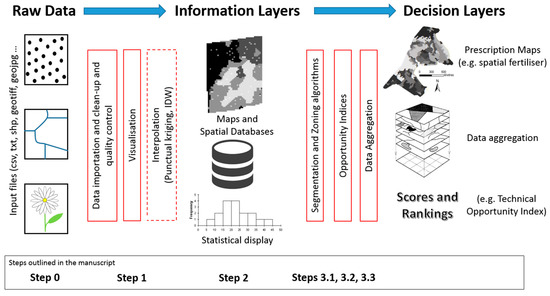
Fig2_Leroux_Agri2018_8-6.jpg (550 × 296 pixels, file size: 85 KB, MIME type: image/jpeg)
Summary
| Description |
Figure 2. Generic flow of data in precision agriculture with main processing steps from raw data processing to decision-making |
|---|---|
| Source |
Leroux, C.; Jones, H.; Pichon, L.; Guillaume, S.; Lamour, J.; Taylor, J.; Naud, O.; Crestey, T.; Lablee, J.-L.; Tisseyre, B. (2018). "GeoFIS: An open-source decision support tool for precision agriculture data". Agriculture 8 (6): 73. doi:10.3390/agriculture8060073. |
| Date |
2018 |
| Author |
Leroux, C.; Jones, H.; Pichon, L.; Guillaume, S.; Lamour, J.; Taylor, J.; Naud, O.; Crestey, T.; Lablee, J.-L.; Tisseyre, B. |
| Permission (Reusing this file) |
|
| Other versions |
Licensing
|
|
This work is licensed under the Creative Commons Attribution 4.0 License. |
File history
Click on a date/time to view the file as it appeared at that time.
| Date/Time | Thumbnail | Dimensions | User | Comment | |
|---|---|---|---|---|---|
| current | 19:49, 10 July 2018 | | 550 × 296 (85 KB) | Shawndouglas (talk | contribs) |
You cannot overwrite this file.
File usage
The following 2 pages use this file:


