File:Fig3 D'Anca NatHazEarth2017 17-2.png
Original file (780 × 612 pixels, file size: 133 KB, MIME type: image/png)
Summary
| Description |
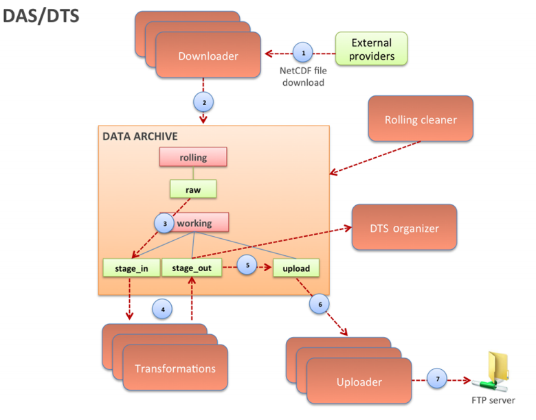
Figure 3. Interactions between the DAS, the DTS and the data archive |
|---|---|
| Source |
D'Anca, A.; Conte, L.; Nassisi, P.; Palazzo, C.; Lecci, R.; Cretì, S.; Mancini, M.; Nuzzo, A.; Mirto, M.; Mannarini, G.; Coppini, G.; Fiore, S.; Aloisio, G. (2017). "A multi-service data management platform for scientific oceanographic products". Natural Hazards and Earth System Sciences 17 (2): 171-184. doi:10.5194/nhess-17-171-2017. |
| Date |
2017 |
| Author |
D'Anca, A.; Conte, L.; Nassisi, P.; Palazzo, C.; Lecci, R.; Cretì, S.; Mancini, M.; Nuzzo, A.; Mirto, M.; Mannarini, G.; Coppini, G.; Fiore, S.; Aloisio, G. |
| Permission (Reusing this file) |
|
| Other versions |
Licensing
|
|
This work is licensed under the Creative Commons Attribution 3.0 Unported License. |
File history
Click on a date/time to view the file as it appeared at that time.
| Date/Time | Thumbnail | Dimensions | User | Comment | |
|---|---|---|---|---|---|
| current | 22:18, 25 April 2017 | | 780 × 612 (133 KB) | Shawndouglas (talk | contribs) |
You cannot overwrite this file.
File usage
The following page uses this file:


