File:Fig4 Oyashi GeospatialHlth2019 14-1.png
Original file (950 × 450 pixels, file size: 200 KB, MIME type: image/png)
Summary
| Description |
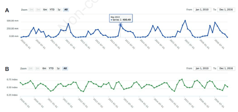
Figure 4. Examples of point search results. (A) Rainfall around Dhaka, Bangladesh (N 23.823, E 90.414); (B) Normalized Difference Vegetation Index for cropland around Kisum, Kenya (S 0.122, E 34.293). |
|---|---|
| Source |
Oyashi, K.; Mizukami, Y.; Kakuda, R.; Kobayashi, Y.; Kai, H.; Tadono, T. (2019). "Japan Aerospace Exploration Agency’s public-health monitoring and analysis platform: A satellite-derived environmental information system supporting epidemiological study". Geospatial Health 14 (1): 717. doi:10.4081/gh.2019.717. |
| Date |
2019 |
| Author |
Oyashi, K.; Mizukami, Y.; Kakuda, R.; Kobayashi, Y.; Kai, H.; Tadono, T. |
| Permission (Reusing this file) |
Creative Commons Attribution-NonCommercial 4.0 International |
| Other versions |
Licensing
|
|
This work is licensed under the Creative Commons Attribution-NonCommercial 4.0 International License. |
File history
Click on a date/time to view the file as it appeared at that time.
| Date/Time | Thumbnail | Dimensions | User | Comment | |
|---|---|---|---|---|---|
| current | 17:07, 6 August 2019 | | 950 × 450 (200 KB) | Shawndouglas (talk | contribs) |
You cannot overwrite this file.
File usage
The following page uses this file:


