Difference between revisions of "File:Fig1 Oyashi GeospatialHlth2019 14-1.png"
Shawndouglas (talk | contribs) |
Shawndouglas (talk | contribs) (Added summary.) |
||
| Line 1: | Line 1: | ||
==Summary== | |||
{{Information | |||
|Description='''Figure 1.''' Overview of the satellite-derived environmental information provision system (JPMAP). JPMAP users can send queries to the system via the JPMAP website user interface, which results in spatio temporal processing of archived data. Users can also generate time- series plots based on query results and download time-series data. JAXA, Japan Aerospace Exploration Agency; NASA/USGS, National Aeronautics and Space Administration/United States Geological Survey; GSMap, Global Satellite Mapping of Precipitation; JASMES, Satellite Monitoring for Environmental Studies; AW3D30, Advanced Land Observing Satellite World 3D-30; GADM, Global Administrative Areas database. | |||
|Source={{cite journal |title=Japan Aerospace Exploration Agency’s public-health monitoring and analysis platform: A satellite-derived | |||
environmental information system supporting epidemiological study |journal=Geospatial Health |author=Oyashi, K.; Mizukami, Y.; Kakuda, R.; Kobayashi, Y.; Kai, H.; Tadono, T. |volume=14 |issue=1 |pages=717 |year=2019 |doi=10.4081/gh.2019.717}} | |||
|Author=Oyashi, K.; Mizukami, Y.; Kakuda, R.; Kobayashi, Y.; Kai, H.; Tadono, T. | |||
|Date=2019 | |||
|Permission=[http://creativecommons.org/licenses/by-nc/4.0/ Creative Commons Attribution-NonCommercial 4.0 International] | |||
}} | |||
== Licensing == | == Licensing == | ||
{{cc-by-nc-4.0}} | {{cc-by-nc-4.0}} | ||
Latest revision as of 00:09, 6 August 2019
Summary
| Description |
Figure 1. Overview of the satellite-derived environmental information provision system (JPMAP). JPMAP users can send queries to the system via the JPMAP website user interface, which results in spatio temporal processing of archived data. Users can also generate time- series plots based on query results and download time-series data. JAXA, Japan Aerospace Exploration Agency; NASA/USGS, National Aeronautics and Space Administration/United States Geological Survey; GSMap, Global Satellite Mapping of Precipitation; JASMES, Satellite Monitoring for Environmental Studies; AW3D30, Advanced Land Observing Satellite World 3D-30; GADM, Global Administrative Areas database. |
|---|---|
| Source |
Oyashi, K.; Mizukami, Y.; Kakuda, R.; Kobayashi, Y.; Kai, H.; Tadono, T. (2019). "Japan Aerospace Exploration Agency’s public-health monitoring and analysis platform: A satellite-derived environmental information system supporting epidemiological study". Geospatial Health 14 (1): 717. doi:10.4081/gh.2019.717. |
| Date |
2019 |
| Author |
Oyashi, K.; Mizukami, Y.; Kakuda, R.; Kobayashi, Y.; Kai, H.; Tadono, T. |
| Permission (Reusing this file) |
Creative Commons Attribution-NonCommercial 4.0 International |
| Other versions |
Licensing
|
|
This work is licensed under the Creative Commons Attribution-NonCommercial 4.0 International License. |
File history
Click on a date/time to view the file as it appeared at that time.
| Date/Time | Thumbnail | Dimensions | User | Comment | |
|---|---|---|---|---|---|
| current | 00:05, 6 August 2019 | 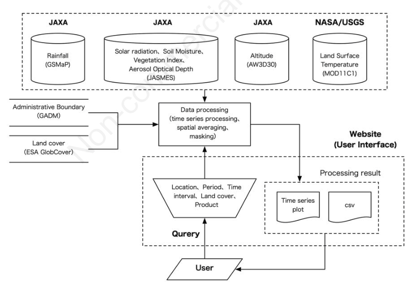 | 832 × 579 (179 KB) | Shawndouglas (talk | contribs) |
You cannot overwrite this file.
File usage
The following page uses this file:


