Difference between revisions of "File:Fig9 Leroux Agri2018 8-6.png"
Shawndouglas (talk | contribs) (Added summary.) |
Shawndouglas (talk | contribs) |
||
| Line 1: | Line 1: | ||
==Summary== | ==Summary== | ||
{{Information | {{Information | ||
|Description='''Figure 9.''' Maps of the whole-vineyard showing the spatial variability in ('''a''') elevation; ('''b''') soil apparent conductivity (ECa); and ('''c''') vegetative expression (normalized difference vegetation index (NDVI)). Points in ('''a''', '''b''') indicate sampling locations (''n'' = 256) (reproduced with permission from | |Description='''Figure 9.''' Maps of the whole-vineyard showing the spatial variability in ('''a''') elevation; ('''b''') soil apparent conductivity (ECa); and ('''c''') vegetative expression (normalized difference vegetation index (NDVI)). Points in ('''a''', '''b''') indicate sampling locations (''n'' = 256) (reproduced with permission from Santesteban ''et al.''). | ||
|Source={{cite journal |title=GeoFIS: An open-source decision support tool for precision agriculture data |journal=Agriculture |author=Leroux, C.; Jones, H.; Pichon, L.; Guillaume, S.; Lamour, J.; Taylor, J.; Naud, O.; Crestey, T.; Lablee, J.-L.; Tisseyre, B. |volume=8 |issue=6 |pages=73 |year=2018 |doi=10.3390/agriculture8060073}} | |Source={{cite journal |title=GeoFIS: An open-source decision support tool for precision agriculture data |journal=Agriculture |author=Leroux, C.; Jones, H.; Pichon, L.; Guillaume, S.; Lamour, J.; Taylor, J.; Naud, O.; Crestey, T.; Lablee, J.-L.; Tisseyre, B. |volume=8 |issue=6 |pages=73 |year=2018 |doi=10.3390/agriculture8060073}} | ||
|Author=Leroux, C.; Jones, H.; Pichon, L.; Guillaume, S.; Lamour, J.; Taylor, J.; Naud, O.; Crestey, T.; Lablee, J.-L.; Tisseyre, B. | |Author=Leroux, C.; Jones, H.; Pichon, L.; Guillaume, S.; Lamour, J.; Taylor, J.; Naud, O.; Crestey, T.; Lablee, J.-L.; Tisseyre, B. | ||
Latest revision as of 22:08, 10 July 2018
Summary
| Description |
Figure 9. Maps of the whole-vineyard showing the spatial variability in (a) elevation; (b) soil apparent conductivity (ECa); and (c) vegetative expression (normalized difference vegetation index (NDVI)). Points in (a, b) indicate sampling locations (n = 256) (reproduced with permission from Santesteban et al.). |
|---|---|
| Source |
Leroux, C.; Jones, H.; Pichon, L.; Guillaume, S.; Lamour, J.; Taylor, J.; Naud, O.; Crestey, T.; Lablee, J.-L.; Tisseyre, B. (2018). "GeoFIS: An open-source decision support tool for precision agriculture data". Agriculture 8 (6): 73. doi:10.3390/agriculture8060073. |
| Date |
2018 |
| Author |
Leroux, C.; Jones, H.; Pichon, L.; Guillaume, S.; Lamour, J.; Taylor, J.; Naud, O.; Crestey, T.; Lablee, J.-L.; Tisseyre, B. |
| Permission (Reusing this file) |
|
| Other versions |
Licensing
|
|
This work is licensed under the Creative Commons Attribution 4.0 License. |
File history
Click on a date/time to view the file as it appeared at that time.
| Date/Time | Thumbnail | Dimensions | User | Comment | |
|---|---|---|---|---|---|
| current | 22:05, 10 July 2018 | 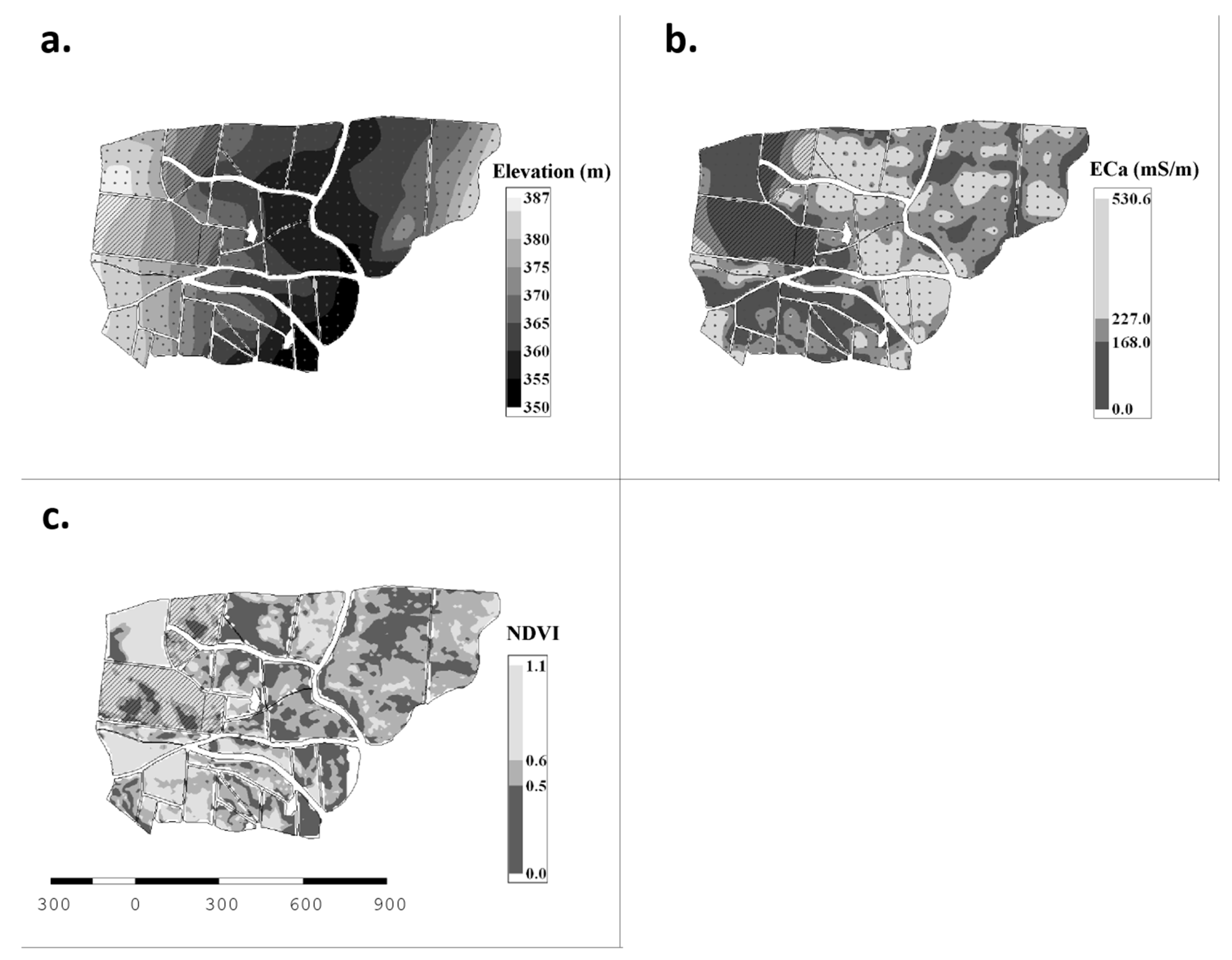 | 3,480 × 2,710 (963 KB) | Shawndouglas (talk | contribs) |
You cannot overwrite this file.
File usage
The following page uses this file:


