Template:Article of the week
"GeoFIS: An open-source decision support tool for precision agriculture data"
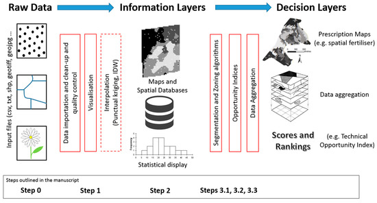
The world we live in is an increasingly spatial and temporal data-rich environment, and the agriculture industry is no exception. However, data needs to be processed in order to first get information and then make informed management decisions. The concepts of "precision agriculture" and "smart agriculture" can and will be fully effective when methods and tools are available to practitioners to support this transformation. An open-source program called GeoFIS has been designed with this objective. It was designed to cover the whole process from spatial data to spatial information and decision support. The purpose of this paper is to evaluate the abilities of GeoFIS along with its embedded algorithms to address the main features required by farmers, advisors, or spatial analysts when dealing with precision agriculture data. Three case studies are investigated in the paper: (i) mapping of the spatial variability in the data, (ii) evaluation and cross-comparison of the opportunity for site-specific management in multiple fields, and (iii) delineation of within-field zones for variable-rate applications when these latter are considered opportune. (Full article...)
Recently featured:
